
Understanding the risks and insurance implications in a changing climate
Introduction
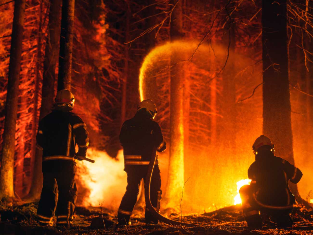
Wildfire events pose significant risks to life, property and the environment, and have profound implications for insurance underwriting, claims handling and risk modelling, according to the National Fire Chiefs Council. The changing climate — including hotter, drier summers and more intense rainfall during the rest of the year — has exacerbated this trend. Areas such as the Scottish Highlands, parts of Wales and the South of England have seen a notable rise in wildfire incidents. These fires threaten both rural and urban properties, and present new challenges for insurers who must adapt to this evolving risk landscape.
One leading insurer reported that farm fire costs in the UK during the dry summer of 2018 amounted to nearly £32 million, marking a 137% increase compared to 2017. Additionally, the overall cost of claims for farm fires during the harvest period rose by 21%, reaching £5.5 million (Ecosulis and Farmlytics, 2019).
Validated Woodland Carbon Code (WCC) projects are designed to sequester carbon through woodland creation, with the resulting carbon units sold to organisations seeking to offset their carbon emissions (Forestry Commission, 2023). Under the UK Government’s Woodland Carbon Guarantee scheme, a fixed price of approximately £22.50 per tonne is offered, and a single hectare of woodland can capture around 450 tonnes of CO₂ over a 100-year period (Forest Research, 2022). As the private carbon offset market expands, these projects present both investment opportunities and associated risks. To manage these risks — such as underperformance, fire, disease or storm damage — specialist insurance products are increasingly being developed to protect the carbon yield and financial returns of validated projects (Munich Re, 2021). With the growing number of WCC registrations, demand for such tailored insurance solutions is expected to rise significantly across the sector.
As the occurrence of wildfires rises, it is essential for insurers and loss adjusters to understand the causes and progression of these fires, and the methods available for risk assessment and mitigation, including wildfire prediction systems (University of Exeter, 2023). These systems integrate data on weather conditions, vegetation moisture levels and historical fire patterns to predict high-risk areas, and have become indispensable in forecasting and managing wildfire risks.
This paper explores each of these areas, examines measures to reduce wildfire risks, and shares guidance from the National Fire Chiefs Council to help insurance professionals and fire services develop mitigation strategies for policyholders and affected communities.


Causes of wildfires
Wildfires in the UK are caused by both human and natural factors and their frequency has been increasing in recent years, based on information from the National Fire Chiefs Council. While large-scale wildfires have historically been rare in the UK compared to other regions, a combination of human activity, environmental changes, climate change and urbanisation has contributed to the rise in these incidents (Scottish Government, 2013).
Most wildfires are caused by human actions, whether accidental or deliberate. Arson remains a significant concern, particularly in remote or hard-to-reach areas such as heathlands, moors and forests (Northumberland Fire and Rescue Service, 2022). Malicious fires, often linked to vandalism, can escalate rapidly and may go undetected until they are well advanced.
Accident-related sources
Accidental causes, such as unattended campfires, negligence and carelessness, are common, especially during warm weather when vegetation is dry. Other frequently cited causes include discarded cigarette butts, improperly disposed barbecues, glass bottles and sky lanterns. While these are often reported, they may be misattributed without critical analysis of the vegetation involved and prevailing environmental conditions, according to the National Fire Chiefs Council.
More probable accidental sources include farming activities such as controlled burns or vegetation clearing, which can unintentionally lead to wildfires, particularly under dry or windy conditions. Hot machinery components from tractors or combines can also ignite fires. Infrastructure failures such as faulty power lines or malfunctioning electrical equipment, along with fly-tipping of flammable materials, further elevate the risk (UK Government, 2021).
Forces of nature
While less common, natural factors also contribute to wildfires. Lightning, though rare, can ignite fires in remote or forested areas with dry vegetation. Peat bogs are vulnerable to spontaneous combustion due to microbial activity, leading to smouldering fires that can go undetected for weeks and pose significant challenges for fire services. Haystacks, especially those made from wet or damp hay, are prone to self-heating due to natural oxidation and can also lead to spontaneous combustion, particularly when tightly stacked with insufficient airflow. Similarly, improperly stored animal feed with high moisture content can undergo self-heating and create a fire risk, particularly in poorly ventilated barns.
Wildfire development
Fueled by nature
The start of a wildfire and rate at which it spreads are influenced by several factors, including fuel availability, weather conditions, terrain, aspect, relative humidity and moisture content. Understanding these factors is crucial for predicting fire progression and developing effective mitigation strategies(Northumberland Fire and Rescue Service, 2022).
Unlike fires in buildings or vehicles, wildfires involve the igniting of various types of vegetation, which differ in their arrangement, fuel loads and condition. The fuels involved are both living and dead plant materials, in contrast to the synthetic, manmade materials typically found in buildings. As a result, the likelihood of igniting from various sources differs significantly from that of materials inside a structure.
Wildfires primarily spread through vegetation, including grass, shrubs and trees. In the UK, heathlands, moorlands and forests provide abundant fuel, especially during the summer months when vegetation is dry (Scottish Government, 2013). Common fuel types in the UK and Ireland include grass, crops, non-coniferous woodlands, coniferous woodlands, heath and moorland, scrub and gorse. Each of these fuel types behaves differently in terms of the risk of igniting and the fire spreading.
In the wildfire environment, fuels vary in size, shape and diameter. These fuels can be categorised as either fine fuels or coarse fuels, and their arrangement plays a significant role in determining the rate of fire spread and intensity. The vertical arrangement of fuels ― from ground-level vegetation to the canopy of plantations and crowns of trees ― also influences how fires spread and develop. Decaying vegetation, such as long grass and fallen leaves, increases the risk, as these as these materials ignite more easily under dry, warm conditions.
High temperatures, low humidity and strong winds significantly increase the likelihood of rapid wildfire spread. Recent heatwaves in the UK have exacerbated fire risk by drying out vegetation. Wind plays a key role in fire dynamics by driving the fire, supplying oxygen and drying out moist fuels. It can also cause spotting, distribute smoke, and push flames and smoke columns toward unburnt fuels. Wind direction, particularly the convergence of winds from valleys and hilltop areas, can make fire behaviour unpredictable and challenging to control, especially in areas with frequent wind shifts.
Hills and valleys
The terrain has a significant impact on wildfire behaviour. Fires spread more quickly uphill due to the movement of heat and the air rising. Radiant heat and convection can preheat fuels, bringing them closer to the temperature for igniting. Fires spreading up a concave slope will increase in speed as the gradient of the slope increases toward its summit. Conversely, fires burning up a convex slope or downhill tend to spread more slowly with less intensity, as the fuels are farther from the flames. Valleys and saddles can affect wind speed and direction by funnelling winds and accumulating heat, which can lead to faster spreading fires. Steep, hilly terrain presents unique challenges for firefighting crews and increases the risk to properties in these areas.
The direction a slope faces relative to the sun, or its aspect, influences wildfire development. South-facing slopes, exposed to more solar radiation, dry out faster and have preheated fuels that are more prone to igniting. This increases the fire’s intensity. In contrast, north-facing slopes tend to be more shaded and retain moisture, making them less susceptible.
Weather conditions
Relative humidity is a critical factor influencing wildfire behaviour in the UK, particularly during dry and hot conditions. Low relative humidity decreases the moisture content in vegetation, increasing its flammability and the likelihood of igniting. This effect is especially pronounced in fine fuels like grass, heather and gorse, which are prevalent in heathlands and moorlands (Scottish Government, 2013).
The Fire Weather Index is a key tool used by the UK’s national meteorological service, the Met Office, that incorporates relative humidity to assess fire danger levels. The Met Office suggests that a decrease in relative humidity is strongly correlated with an increase in the frequency of very high fire danger days. For instance, at a 4°C global warming scenario, the frequency of such days in England could increase fivefold compared to historical levels.
Wildfire prediction systems
In recent years, wildfire prediction systems have been developed to help manage wildfire risks by forecasting the likelihood of fires in specific areas. These systems integrate data from satellite imagery, weather forecasts, historical fire records and climate models to identify high-risk zones. This enables fire services to allocate resources more efficiently and helps insurers assess risks and adjust policies accordingly.
The UK’s wildfire prediction system is based on the Campbell Prediction System, a proven framework from the U.S. that predicts wildfire behaviour. It has been adapted to account for the UK’s unique environmental conditions, including diverse vegetation, varied terrain and specific weather patterns, according to (Campbell, the National Fire Chiefs Council, and Scottish Government.
The system evaluates weather conditions, fuel availability and terrain features, and analyses how they interact to influence fire dynamics. Doug Campbell, the author of “Campbell Prediction System, A Wildland Fire Prediction and Communication System,” concluded that wildfires often occurred when wind, slope and aspect aligned ― a phenomenon he termed the forces of alignment (Figure 1).

Figure 1: Forces of Alignment (Scottish Government 2013)
These alignment factors affect the way a fire burns within a fuel complex and can be classified as follows:
F0: A fire with none of the alignment factors acting in its favour, burning with equal intensity in all directions; considered “out of alignment”
F1: A fire driven by wind, but not burning up a slope or in aspect
F2: A fire driven by wind and burning up a slope, but not in aspect
F3: A fire with all three factors acting in its favour: wind-driven, burning up a slope and in aspect (as shown in Image 1)

Image 1: An F3 wind-driven fire, up a slope and in aspect (Scottish Government, 2013)
Fire alignment factors can be annotated on the map to show where the high-risk areas are in relation to slope and aspect, and how the severity of risk may change due to time of day and changes in wind direction (Figure 5).
The wildfire prediction system is an essential tool for fire and rescue services to forecast fire behaviour and develop effective firefighting strategies. It also provides valuable insights for risk management professionals who use the system to identify high-risk areas and implement proactive measures to reduce wildfire risks.

Figure 5: Alignments show where there may be significant changes to fire alignments and fire behaviour (Scottish Government, 2013)
Risk assessment for wildfires
For the insurance sector, comprehensive risk assessments and the implementation of mitigation measures are indispensable. By evaluating these factors, insurers can accurately price policies and advise clients on strategies for loss prevention and mitigation.
When assessing the likelihood and severity of wildfires, the following factors should be considered:
1.
Location analysis: Properties located on south facing slopes (essentially F2 fire alignments) and near heathlands, moorlands, woodlands or grasslands are at higher risk, especially if there is dense vegetation and combustible material nearby. Areas with a history of frequent wildfires or those that experience prolonged dry conditions are considered higher risk.
2.
Building and construction evaluation: Properties built from combustible materials such as wood or thatch are more vulnerable to wildfire damage compared to those made from fire-resistant materials like brick, concrete or metal. Properties with overhanging trees, dry brush or debris on roofs are especially susceptible to ember attacks. On the other hand, properties near well-maintained firebreaks benefit from added protection as these barriers help prevent the spread of fire.
3.
Weather and environmental factors: Weather data, such as temperature, humidity and wind speed, should be integrated into risk assessment models. Dry, hot and windy conditions significantly increase the likelihood of fire spread. Additionally, peat bogs, especially when dry, are prone to smouldering fires that are difficult to detect and control.
4.
Firefighting resources: The availability and accessibility of firefighting resources play a vital role in wildfire suppression. Access to sufficient water supplies (such as hydrants, rivers and lakes) and the ability to reach remote areas influences the effectiveness of firefighting efforts. Areas lacking firefighting infrastructure are at higher risk and require greater preparation and resources.
Mitigation measures help reduce the overall wildfire risk and control the impacts of fires. Property owners and land management companies can lower the likelihood and severity of wildfire damage to their properties by implementing the following strategies:
1.
Vegetation and fuel load management: Property owners should regularly clear dry leaves, grass and branches to reduce the fuel load for wildfires. Effective strategies include controlled burns, grazing and thinning dense vegetation. Local councils and landowners should also manage hedgerows actively. When doing so, it is essential to balance fire prevention efforts with biodiversity conservation and the maintenance of ecological landscapes. This ensures fire hazards are reduced while promoting environmental sustainability. Councils should also take measures to control fly-tipping, which can contribute to increased wildfire risk. Planting fire-resistant vegetation and establishing fire buffers around properties can further reduce fire hazards. Additionally, haystacks and animal feed should be stored properly, ensuring they are well-ventilated and kept dry to prevent fire risks.
2.
Firebreaks: Firebreak zones, also known as defensible spaces, are cleared areas that interrupt the fuel source, preventing the spread of fire. Property owners in high-risk areas should create firebreaks around their homes, especially near storage areas, forests and roads. These firebreaks should be regularly maintained and strategically placed. Safe distances are based on research considering vegetation type, slope, weather conditions and building materials. While standards may vary globally, here is a UK-specific summary of recommended safe distances supported by research and fire safety organisations:
- 30 metres of defensible space around structures is considered a baseline for high-risk areas. This space should be managed to reduce the fuel load, such as by removing dead vegetation, thinning trees and spacing shrubs.
- Within the first 10 metres: Keep this area lean and clean by maintaining short grass and non-combustible landscaping, and ensuring no flammable materials are stored near buildings.
- Slope matters: On steep slopes, fires spread faster uphill, so it is recommended to increase the defensible space by up to 1.5 to 2 times the minimum distance (i.e., 45–60 metres).
- Fuel breaks or fire belts (50–100 metres wide): These are strategically cleared or managed strips of land designed to slow or stop the spread of fire, particularly in heathland, moorland or forest settings.
- Woodland Wildfire Buffer Zones (used in Forestry England and National Trust management): Typically, 20–50 metres with reduced undergrowth and increased tree spacing.
- UK electricity distribution network operators must comply with the Electricity Safety, Quality and Continuity Regulations (ESQCR). Minimum clearance for wildfire-prone areas is recommended to be between 5–10 m. Similar to fuel breaks around buildings, substations and key pylons should have 10–30 m vegetation clearance (with gravel or low-fuel landscaping), and access tracks must be kept free of combustible debris. Additionally, fire-resistant fencing and protective mesh are advised.
Figures 6 and 7 depict typical safe distances based on current wildfire prevention research and standard guidance used in the UK and internationally. These reflect key principles from:
- UK Fire and Rescue Service wildfire safety guidance (e.g., National Fire Chiefs Council and Scottish Fire and Rescue Service)
- Forestry England and National Trust woodland management practices
- Defensible space recommendations adapted from international best practices, including those from CAL FIRE and Australia’s CSIRO
- Academic research, such as that from the University of Exeter’s Wildfire Lab

Figure 6 shows safe distances around buildings
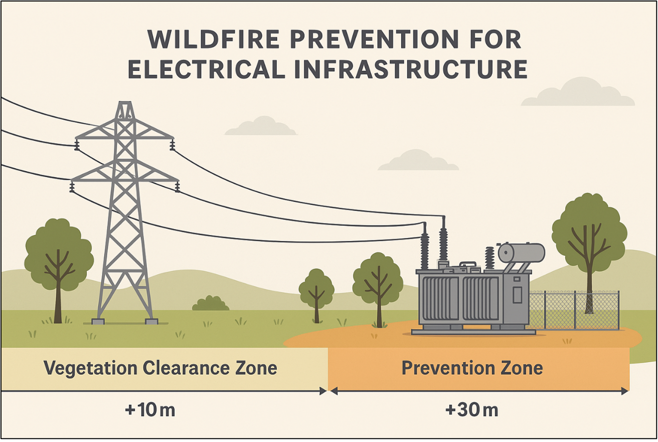
Figure 7 shows safe distances around electrical infrastructure
The Scottish Fire and Rescue Service and England’s Wildfire Tactical Advisors recommend tailoring these distances depending on vegetation, fire weather index and wind direction.
Ongoing research, including work by the University of Exeter’s Wildfire Lab and DEFRA-sponsored land resilience programmes, continues to refine these recommendations using AI modelling and post-incident analysis.
3.
Fire-resistant construction and landscaping: Using fire-resistant materials (e.g., non-combustible roofing, windows and walls) significantly reduces a property’s vulnerability to wildfires. Fire-resistant landscaping practices, such as using non-combustible plants and clearing debris, can help prevent the spread of fire. Creating defensible spaces around homes with fire-resistant materials is another key strategy.
4.
Public awareness and fire safety: Educating the public about fire safety is essential in reducing human-caused wildfires. Property owners should inform family members and neighbours about fire safety practices, including safe campfire management and proper disposal of cigarette butts. Public education campaigns should emphasize fire safety, especially during high-risk fire seasons.
5.
Peatland and moisture management: Peat bogs are highly susceptible to spontaneous combustion, particularly in dry conditions. Property owners near peat bogs should collaborate with local authorities to regulate water levels and control vegetation to reduce the risk of spontaneous combustion. Controlled water flow and other techniques can help prevent peat from drying out and igniting.
6.
Fire retardants and firefighting technologies: Fire retardants — both chemical and natural — help slow the spread of wildfires. Property owners in high-risk areas should consult with local fire services about applying these retardants around their properties. Fire-retardant gels and coatings can be used on homes, outbuildings and critical infrastructure to create temporary fire barriers.
Additionally, retardants applied to vegetation or vulnerable landscapes can reduce the risk of fire igniting and spreading. These can be applied days or weeks in advance to areas like roadside vegetation, utilities (e.g., power lines), and wildland-urban interface zones. They can be sprayed from trucks, ATVs or aircraft and remain effective until washed away by heavy rain. However, concerns about the environmental impact and cost-effectiveness have led to delays in their use. Eco-friendly, biodegradable and non-toxic pre-fire retardants, such as cellulose-based retardants and biopolymer gels, are gaining popularity as more environmentally responsible alternatives.
7.
Community preparedness: Strong community-wide preparedness ensures that neighbourhoods are equipped to handle wildfire risks collectively. Property owners should work together to implement fire-resistant landscaping and shared firebreaks, and participate in community wildfire awareness programs and emergency preparedness drills. By collaborating, communities can greatly enhance fire prevention and mitigation efforts.
8.
Firefighting facilities and technologies: Supporting advancements in firefighting technologies ― such as drones, satellite imaging and early detection systems ― improves wildfire response time and reduces overall damage. These technologies can help fire services detect fires earlier, allocate resources more effectively, and respond more efficiently to mitigate wildfire risks.
Conclusion
Effectively mitigating wildfire risk requires a comprehensive approach that integrates environmental protection with proactive fire prevention strategies. A thorough wildfire risk assessment is essential for evaluating the factors that influence both the likelihood and severity of a fire. This process helps identify vulnerable areas, facilitates the development of effective mitigation strategies, and informs fire prevention and response planning. By understanding these underlying risks, insurers can assess property exposure, estimate the probability of wildfire events, and forecast potential damage severity.
Incorporating factors from wildfire prediction systems, such as slope, aspect and wind, into insurance risk assessments enhances the understanding of wildfire exposure across diverse landscapes. By implementing measures like vegetation management, firebreaks, fire-resistant construction and community preparedness through education and fire-safe landscaping, the impact of wildfires can be significantly minimised. Properties located on steep or south-facing slopes, and those exposed to prevailing winds, may need tailored risk reduction strategies. Identifying such high-risk zones allows insurers to collaborate with policyholders, helping to reduce vulnerability and enhance resilience against wildfires.
The future of wildfire prevention combines eco-friendly materials, smart technology and coordinated response systems. Biodegradable fire retardants and plant-based gels are replacing harmful chemicals, while AI and machine learning help predict fire risks, detect early outbreaks and support real-time response. Drones provide thermal imaging, surveillance and post-fire assessment, even in remote areas. In the UK, where wildfires are rising due to hotter, drier summers, national efforts include the National Fire Chiefs Council’s wildfire strategy, enhanced AI-driven Fire Severity Index from the Met Office and drone use by fire services. Land managers like the National Trust and Forestry England are adopting controlled burns and rewilding to reduce fuel loads. UK universities and wildfire research groups are also providing valuable local insight and training. These innovations collectively support earlier detection, more effective incident response, and long-term wildfire resilience.
The insurance industry plays a pivotal role in promoting risk-reduction strategies, supporting policyholders in implementing preventive measures, and providing tailored coverage options for areas at high risk of wildfires. By integrating this knowledge with the risk assessment process, insurers can ensure accurate underwriting, pricing and identification of areas where targeted mitigation efforts are needed. This approach helps reduce exposure to wildfire risk while ensuring adequate protection for policyholders.
The National Fire Chiefs Council provides crucial guidance on managing wildfire risks, emphasising a coordinated approach to risk management, including prevention, preparedness, response and recovery. Key points include:
- Risk assessment and preparedness ― Regular risk assessments to identify vulnerable areas
- Cooperation between agencies ― Coordination among fire services, local governments and landowners for effective wildfire management
- Training and public awareness ― Ongoing training for firefighting personnel and public education campaigns to reduce human-caused fires
Contributor
Dave Reed, Senior Forensic Investigator, EFI Global
References
- Natural Capital and Farm Fires Report, Ecosulis and Farmlytics, 2019.
- Woodland Carbon Guarantee, Forestry Commission, 2023.
- Carbon sequestration estimates and woodland creation, Forest Research, 2022.
- Climate-related insurance solutions: Carbon offset projects, Munich Re, 2021.
- Wildfire Prevention and Mitigation Strategy, National Fire Chiefs Council, 2023.
- Campbell Prediction System, A Wildland Fire Prediction and Communication System, 1999.
- University of Exeter, 2023.
- Firewise USA® Program Guide, National Fire Protection Association, 2022.
- Wildfire Prevention Toolkit, Northumberland Fire and Rescue Service, 2022.
- Wildfire Operational Guidance, Scottish Government, 2013.
- Wildfire Risk Assessment Guidelines, UK Government, 2021. Carbon Pricing and Offset Guidelines, UK Government, 2022.